Review Article 
 Creative Commons, CC-BY
The Recommendations are New Indexes and Maps About the Allocation of Hospitals in Years of Urbanization
*Corresponding author: Efthymios Spyridon Georgiou, Company Efthymios Georgiou, 11741, Athens, Greece.
Received: July 24, 2024; Published: August 07, 2024
DOI: 10.34297/AJBSR.2024.23.003099
Abstract
The current paper aims to analyze the spatial analysis of hospitals in the peripheries of Greece. The creation of new indexes has significant meaning because, this way, we study new phenomena and new scientific circumstances. The current medical situation needs to be “read” holistically and multi-science. For instance, the mathematical and cartography approach helps in this direction. The purpose is to create indexes, statistics, and maps of the density of hospitals. The goals are to classify the solid points and disadvantages of the number of hospitals, the spatial equality between the inhabitants, and the area of each district. The software QGIS helps construct digital products (maps, statistics). Also, the visualization of the information is significant in understanding. The Greek healthcare system comprises elements from both the public and private sectors. Although a national health service-type system was established in 1983 in the public sector, it coexists with a social health insurance model. The results are export new indexes, maps, and helpful reviews of the spatial allocation of public hospitals. The current work focuses only on public hospitals. Today, many people live in cities with over 3.000.000 inhabitants. Urbanization increases the density of the inhabitants, the quick daily life, the number of cars, and the increase of information. As a result, the stress and pressure levels increase in the countries capitals and the second – third most prominent cities. In modern statements, district centers, private health hospitals, and small centers offer medical services. The hospitals are the giant medicine pole in each statement. The hospital focuses actions on economic and healthy care for all ages.
The Future Challenges of Greek’s Hospitals
The Greek healthcare system comprises elements from both the public and private sectors. Although a national health service-type system was established in 1983 in the public sector, it coexists with a social health insurance model. The social insurance system consists of a large number of funds and a wide variety of schemes, all of which are under the jurisdiction of the Ministry of Employment and Social Protection (formerly the Ministry of Labour and Social Security [1].
The main problem, not only in the management of socially sensitive services like health care, but also in terms of the overall Greek public management system, is that it has never tried to be financially self-sufficient through a funding system that would reward the “good players” at either the health professionals and employees level or at the institutional-hospital level [2].
The health status of the Greek population has made significant strides over the last few decades, marking a promising trajectory. It compares relatively favorably with other OECD and European Union (EU) countries. The health system is a mixture of the public integrated, public contract, and public reimbursement models, comprising elements from the public and private sectors and incorporating principles of different organizational patterns [1].
This approach is crucial to addressing today’s four central problems: the perverse unaccountability of medical subjectivity, the obsolete management model, the lack of human resources management tools, and the unhealthy financing of hospitals. Tomorrow’s hospital would respect the autonomy of the medical profession while at the same time demanding scientific accountability and utilizing modern organizational tools to manage its human resources to produce quality, effective, and efficient services. [2] Strategic planning assumptions are specific to each proposed action plan. The hospitals include the following: all local and federal laws and regulations related to building healthcare facilities are followed, and all new facilities are inspected by and meet public health criteria [3].
The Meaning of Visualization of Hospitals in Greece
Nowadays, realistic visualization solutions exist. In an era of information overload, many people need help making sense of complex stories [4]. Digital documentation is crucial because it helps understand and review the spatial analysis and classification of hospitals. The digital era allows the following decisive advantages.
1) Quickly spread information.
2) Globally knowledge.
3) Various and varied texts, videos, tables.
4) Visualization of information. For instance, photographs and videos.
5) Historical storage.
6) Artificial intelligent.
7) Big authenticity. For instance, government websites.
In recent years, people’s daily lives have changed. Humanity is facing new challenges [5]. Phase visualization was initially used to refer to visualization as part of scientific computing, which is the use of computer modeling and simulation in computing and engineering practice [6].
The Significant New Indexes
The creation of new indexes has significant meaning because, this way, we study new phenomena and new scientific circumstances. The current medical situation needs to be “read” holistically and multi-science. For instance, the mathematical and cartography approach helps in this direction. Medicine needs to become a main priority in the countries because of the long life of the people, the body’s health condition, the security of the surgical decisions, and the scientific education not only for the hospital staff but also the population. For instance, the decrease in the stress level has significant meaning in times of urbanization. Today, many people live in cities with over 3.000.000 inhabitants.
The urban environment affects health and well-being. We consider two key dimensions: urbanization and urbanicity. Urbanization refers to changes in cities’ size, density, and heterogeneity. Urbanicity refers to the impact of living in urban areas at a given time [7]. Urbanization increases the density of the inhabitants, the quick daily life, the number of cars, and the increase of information. As a result, stress and pressure levels increase in the countries’ capitalization and the second – third most prominent cities. A healthy organization needs to create action education in the human population about this theme. Medicine science often has a role in spatial making decisions. The suggested new indexes are the following:
Mathematics Models
a) Percentage (%) Hospitals per Area
b) Percentage (%) Hospitals per Populations
Cartography
a) Hospitals per Peripheries,
b) Allocation of hospitals in Greece
The Methodology of Digital Maps
The cartography, particularly by those interested in reexamining the role of aesthetics, design, and visual expression in cartography. Two basic approaches to ‘art’ and ‘science’ in the context of cartography and information graphics are described along with their limitations [8]. The methodology is based on the vector datasets. It designs the point-shape files of the hospitals, including information about the number of hospitals, the name, the area, and the population of the peripheries. The attribute tables add new fields and the values corresponding to them in the periphery. The number of classes is very significant because there are equal export results. The spatial harmony in the Greek land depends on the two main cities and the metropolitan areas of these cities. These cities are in North and South Greece, and this geomorphology phenomenon creates equality among the inhabitants. Also, ten cities contain 70- 80% of the population.
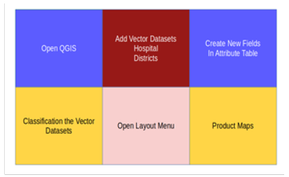
The metropolitan areas of Thessaloniki and Athens include over 60% of the population. The phenomenon of urbanization creates problems and increases needs because the density is very huge. For these reasons, there are high-quality medicine services in Peripheries Thessalia, Epirus, and Thrace. The strategic location of the universities in the capitals of the peripheries Ioannina, Larisa, has a functional and organizational role in the proper allocation of the hospitals. Figure 1 shows the steps of the construction maps in the software Geographic Information Systems, especially in QGIS. The QGIS is open–source software that is widely used by audiences. The QGIS has the logic of the community and free download fees (Figure 1).
The Synopsis of the New Statistics and Maps
The hospitals in Greece automatically find the software QGIS with the tool to find the address. The user imports the Excel and configures the parameters depending on the municipality. A percentage is wrong, 10%-12%, because the software does not recognize the city in many regions of Greece. The following maps describe the situation with trust, 88%-90% (Figures 2,3).
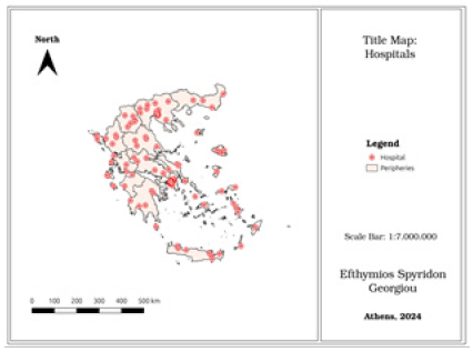
Figure 2 shows the number of hospitals per district. The most significant number is near the most prominent cities, Athens and Thessaloniki. The metropolitan area of Thessaloniki has 19 hospitals, and the metropolitan area of Athens has 61. The number of hospitals in the Aegean Archipelagos is high enough. There are eight hospitals in South Aegean, and in North Aegean, there are five. The number of hospitals is listed on the official website of Greek governance. According to the map, green focuses on the metropolitan areas with the largest population. Figure 3 shows the spatial allocation of the hospitals for each district. The map includes the symbol of the North, the legend, the scale bar, the city of construction, and the map title (Figure 4,5).
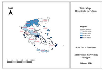
Figure 4 shows the hospital per area. The districts Attiki located in Athens have a better percentage of hospitals. Also, the South Aegean and Ionian archipelagos are in the same class as Attiki. The lowest values are in Peloponnese, We, Thessalian, and West Greece. The map has four classes; the lowest class is 0.035-0.042, and the most significant class is 0.13-0.602. That means the blue class’s analogy between area and hospital is better.
Figure 5 shows the analogy between the hospitals and inhabitants. The better analogy is in the district of Epirus, which is green and has the values 0.002-0.013. That means that each hospital corresponds to 0.002-0.013 per 100 inhabitants.
Challenges and Opportunities from Spatial Allocation in Hospitals
Maps have long been instrumental in understanding location- based phenomena. They visually represent intangible human aspects, such as population distributions, and tangible physical elements, like rainfall, across different areas. Moreover, they offer insights into geographical processes, such as urban growth, as they unfold over time. These unique capabilities make maps indispensable in collaborative spatial decision‐making environments, where group members work together to address semi‐structured problems with distinct geographic visualization needs.
The former deals with selective aspects of contemporary cartography development, such as user interfaces and cartographic generalization streams. There are some ideas and new challenges in cartography science. Technological progress brings changes in the way people think and solve problems.
Cartography is a field in constant evolution. It’s not just about creating two-dimensional maps anymore. The focus is now on the development of three-dimensional maps and models, as well as on new and still hypothetical investigations of recognition. The potential use of cognitive styles in cartography further underscores the field’s dynamism and the ongoing quest for innovative solutions.
Several organizations are developing such measures - for example, Medicare’s Physician Group Practice Demonstration recently released data incorporating measures of cost and quality concerning the management of specific conditions; the Centers for Medicare and Medicaid Services is developing “value scores” for physicians based on quality performance and resource use; the National Committee on Quality Assurance publishes health-plan-level “Relative Resource Utilization” measures for various conditions; and Prometheus Payment has developed approaches to prospective payment that reward efficiency by enabling providers to share in savings for avoiding complications [9-12].
Results
The results of the current paper focus on the design indexes and empirical analysis of the medical situation in Greece. The creation maps in QGIS present the number of hospitals, the hospitals per area, the hospitals per population, and the hospitals per peripheries. The indexes show the number of hospitals per 100 inhabitants and the percentage number of hospitals per area. The digital products are a smart and innovative way to present the current situation in hospitals. The indexes show the disadvantages and advantages of the allocation of hospitals in Greece. The software QGIS has powerful tools for the visualization of the earth. Visualization and export statistics are some skills for the users.
To summarize, the allocation of hospitals in Greece offers opportunities for a better understanding of the regions and the level of the number of hospitals and their services. However, in years of urbanization, there is intense pressure and stress in huge cities. The quick daily life, the level of air and sound pollution, the lot of information in social media and newspapers, and the various and varied information near the home inhabitants are negative factors of sustainable development that we must be aware of and address.
Discussion
The current work produces new ideas, priorities, and actions about the meaning of multi-science in medicine. The cartography and the mathematical statistics offer a better understanding of the hospital’s spatial reality. Also, the future is in our hands. This means that recognizing hospital allocation is a crucial factor in years of urbanization. Humanity is called to give answers to the questions and challenges about the high density in terra and big cities, as well as the solving of the quality and quick medicine service in the population. For instance, in Greece, there is the following phenomenon. The biggest cities have skilled doctors and many hospitals compared to the islands and small cities. As a result, the inhabitants of Greek islands have limited medical services, and they have often changed the cities for health care.
Also, the big hospitals in Athens and Thessaloniki need good economic balance and management. The costs of preserving hospital departments are highest in these hospitals. Nowadays, with new technology and equipment, the costs are directed towards covering people’s needs.
In the summer, a significant number of tourists in need of medical services are observed. The long journey to the Greek islands, high temperatures, physical exertion, alcohol consumption, unfamiliar road systems, and cultural differences are all critical factors that must be considered in healthcare planning. There is a clear need for strategic planning that takes into account tourist behavior and education. For example, when visitors from colder climates arrive on the Greek islands, they need to be informed about the potential impact of heat on their health. Understanding the effects of prolonged walking, dehydration, and the importance of regular water consumption can help protect these tourists. These are issues that doctors, tourists, tour groups, and hospitals need to be aware of and prepared for.
In conclusion, meeting the future’s needs, which encompass the culture, economy, security, education, and healthcare sectors, requires in-depth factor analyses. The preservation of the hospital environment and the provision of quality medical services demand not just resources, but also political willpower and strategic, hierarchical decisions. It is only through such governance that we can hope to meet the healthcare needs of the planet’s population.
It is significant to note that there are public and private medicine services in Greek medicine management, and in the public hierarchy, there are hospitals, peripheries, and municipal medicine centers. The problem is that the doctors need more hospital staff, and they work grueling hours.
Conclusion
The purpose of this manuscript is to summarize, manage, analyze, and visualize the hospital situation in Greece. The new maps and indexes provide proper measurements to understand the medical situation better. Four maps and indexes present the situation and the points of interest.
In addition, the manuscript describes the opportunities and the challenges in years of urbanization. The health conditions and sustainable development in future cities are crucial factors for the well-being of inhabitants. This approach examines the spatial factors (destiny, transport system, road system), the health level (stress, pressure), and social factors (tourists, education, information).
Finally, the paper refers to the three levels of medicine hierarchy and the kinds. In Greek medicine management, there are international and national hospitals, peripheries of medicine centers, and local municipal centers; they often create comparative comparisons between the cities. For instance, Ioannina, Thessaloniki, and Larisa. This has negative and positive effects. Often, the facilities and the medical staff should be improved. Many times, it creates unfair competition. Also, there are private and public medicine services. There are private dispensaries with very – well services for the inhabitants.
Acknowledgement
Thank the American Journal of Biomedical Science & Research and Ellie W. for the invitation. The journal has high scientific standards and quality, and the authors’ articles express pragmatism on a global level.
Conflict of Interest
None.
References
- Economou C (2010) Greece: Health system review. Health Syst Transit 12(7): 1-177.
- Minogiannis P (2012) Tomorrow’s public hospital in Greece: Managing health care in the post crisis era. Social Cohesion and Development 7(1): 69-80.
- Ike S, Gifford T (2023) Strategic Planning Process Map: Scripps Mercy Hospital Chula Vista.
- Shahaf D, Yang J, Suen C, Jacobs J, Wang H, et al. (2013) Information cartography: creating zoomable, large-scale maps of information. In Proceedings of the 19th ACM SIGKDD international conference on Knowledge discovery and data mining: 1097-1105.
- Georgiou ES (2023) The urbanism and geography in green regions of Europe. Journal of Geography and Cartography 6(2): 2926.
- Post FH, Nielson G, Bonneau GP (2002) (Eds.). Data visualization: The state of the art.
- Vlahov D, Galea S (2002) Urbanization, urbanicity, and health. Journal of Urban Health 79(4 Suppl 1): S1-S12.
- Krygier JB (1995) Cartography as an art and a science? The Cartographic Journal 32(1): 3-10.
- Kraak MJ, Fabrikant SI (2017) Of maps, cartography and the geography of the International Cartographic Association. International Journal of Cartography 3(sup1): 9-31.
- Armstrong MP, Densham PJ (2008) Cartographic support for locational problem‐solving by groups. International Journal of Geographical Information Science 22(7): 721-749.
- Konecny M (2011) Cartography: challenges and potential in the virtual geographic environment’s era. Annals of GIS 17(3): 135-146.
- Bach PB (2010) A map to bad policy-hospital efficiency measures in the Dartmouth Atlas. The New England journal of medicine, 362(7): 569-573.


 We use cookies to ensure you get the best experience on our website.